Mostrando entradas con la etiqueta National Geographic. Mostrar todas las entradas

viernes, 8 de enero de 2016

Cusco, incas, Machu Picchu. Discovering the place for the world

Machu Picchu, the Inca marvel discovered to the world


Machu Picchu (Quechua Machu pikchu, "Old Mountain") is the name of a llaqta or ancient Andean town built in the mid fifteenth century in the rocky promontory that links the Machu Picchu and Huayna Picchu in the eastern slopes of the Cordillera Central, southern Peru and 2490 m, altitude of the main square.


In XVI century documents, it is indicated that Machu Picchu would have been one of the residences rest of Pachacutec, the ninth Inca Tahuantinsuyo between 1438 and 1470. The finest buildings and ceremonial character of the main access road to demonstrate that was llaqta used as a religious sanctuary. Both uses, the palace and the temple, it would have been incompatible. Military character which connotes the adjectives of "strength" or "citadel" is not justified.


Machu Picchu is both a masterpiece of architecture and engineering. Its unique architectural features and landscaping, and the veil of mystery surrounding it have become one of the most popular tourist destinations on the planet.


Machu Picchu is on the List of World Heritage of UNESCO since 1983 as part of a cultural and ecological set called Historic Sanctuary of Machu Picchu. The July 7, 2007 Machu Picchu was declared one of the new seven wonders of the modern world in a ceremony in Lisbon, Portugal.

The definition of Unesco is:

“Located 2,430 meters high in a place of great beauty, in the middle of a tropical mountain forest, the sanctuary of Machu Picchu was probably the most amazing urban creation of the Inca Empire at its height. Its walls, terraces and ramps seem gigantic being carved in the rock cliffs, as if they were part of it. The natural setting, on the eastern slope of the Andes, is part of the upper Amazon basin, which has a varied flora and fauna”.
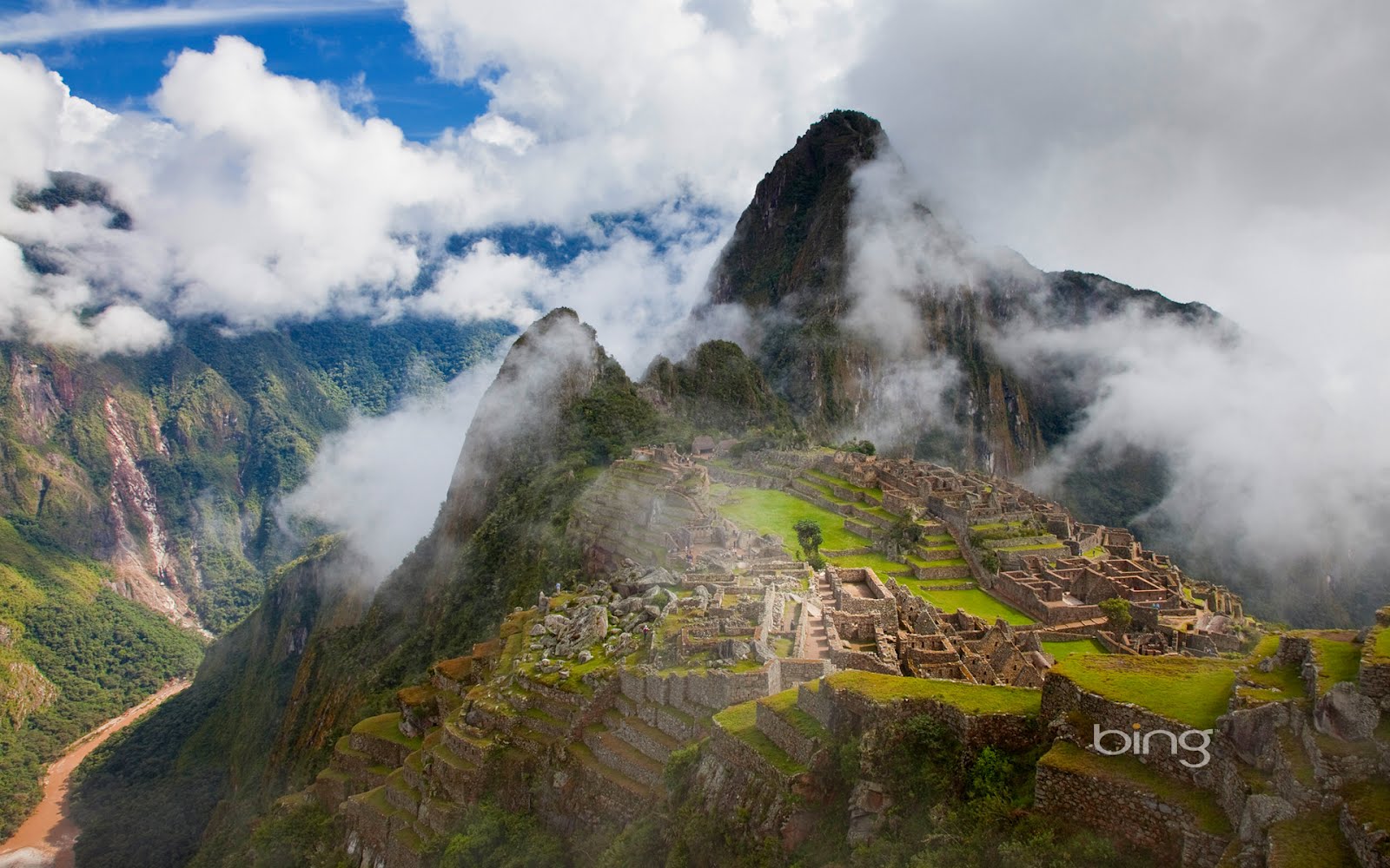


Photo Unesco

The origin is uncertain. Some attribute it to Pachacutec (1438-1470); others argue that Huiracocha Inca ordered the construction of this world wonder (years 1380-1400). It is believed that his poblaciónestaba formed by inhabitants of the elite (the panaca of Pachacutec) and acllas. The agricultural labor force consisted of mitimaes or mitmas settlers (mitmaqkuna) from different corners of the empire.

In 1865, the Italian naturalist Antonio Raimondi passed near the ruins without knowing it. It is also assumed in those years, the area begins to receive visits by interests different from the scientists. Treasure predation had begun. In 1867, the German Augusto Berns not only have "discovered" the ruins but founded a “mining company " to exploit the alleged "treasures" that lodged (Explotadora Company Limited of the Temples of the Inca). Between 1867 and 1870 and with the approval of the government of Jose Balta, the company operated in the area and sold "everything found" to European and American collectors.

At that time maps listed mineral exploration and Machu Picchu. In 1870, the American Harry Singer first recorded on a map of Cerro Machu Picchu and Huayna Picchu referred to as "Punta Huaca del Inca". The name reveals an unusual relationship between the Incas and the mountain and even suggests a religious character (one huaca in the Ancient Andes was a sacred place). A second map of 1874, prepared by the German Herman Gohring, mentions and locates in its exact site both mountains. In 1880 the French explorer Charles Wiener confirmed the existence of archaeological remains in place.


The first direct references on visitors of the ruins of Machu Picchu indicate that Agustín Lizárraga, Cuzco farmer, arrived July 14, 1902 leading the visitors, who left graffiti with their names on one of the walls of the Temple of the Three Windows. One of the graffiti read "Agustin Lizarraga July 14 - 1902", which shows that Lizarraga had discovered Machu Picchu before Bingham, but this is not an unfair gesture gave him credit.

Hiram Bingham (November 19, 1875 - 6 of June 1956) was an explorer and politician United States. He was a professor at Yale when he led an exploration of the South America, where by indications from Lizarraga, rediscovered Machu Picchu.


The discovery took time and money, because he found the ruins after two expeditions. Bingham took fifty thousand archaeological pieces of Machu Picchu to Yale University. A few years ago some of them returned but the destination is uncertain Peru existing public corruption. Perhaps it would have been better off staying at Yale.


Hiram Bingham found irrefutable proof of a previous expedition, and sent delete arguing conservation reasons. He recorded the fact in their travel diaries but "forgot" to point this out in his book "The Lost City of the Incas" published in 1948, which was presented to the world as the sole discoverer of Machu Picchu.


In Photo: Sergeant Carrasco and Pablito Richarte, the child who led Bingham to the ruins (Detail shot of Hiram Bingham's July 24, 1911)


Agustin Lizarraga could not get the recognition he deserved for his prowess, nor their descendants have achieved since the "scientific discoverer" remains the center of attention, despite being officially considered second visitor to the ruins. Winston Churchill said "history is written by the victors," or in this case, the erase and rewrite on it.

Bingham handled the auspices of Yale University, the National Geographic Society and the Peruvian government to initiate the scientific study of the site, conducting archaeological excavations between 1912 and 1915, a period in which the brush is cleared and Inca tombs were excavated in the outskirts from the city. The "public life" of Machu Picchu begins in 1913 with the publication of an article in the journal of the National Geographic.

Although Bingham is questioned his lack of ethics, he had the distinction of being the first person to recognize the importance of the ruins, studying them with a multidisciplinary team and reporting their findings. Is in doubt the scientific approach, reflected in the irregular departure of excavated archaeological material, at least some 46,332 pieces. In any case it was a well planned "scientific plundering". In March 2011 these pieces began to be returned to Peru.

Besides archeology, Martin Chambi, a noted Peruvian photographer, accompanied by Juan Figueroa, between 1924 and 1928 took a series of photographs of Machu Picchu that were published in different Peruvian magazines, massifying local interest on the ruins and turning them into a symbol national. It can be considered a discovery through the image.


Thereafter, the facts that have transformed Machu Picchu on a global appeal, happened quickly. In 1948 a dirt road that climbed the mountain slope to the ruins from the train station was created; in 1981 the ecological protection zone around the ruins is created; in 1983 it happens to be a member of the World Heritage List.


 Teo Allain Chambi, photographer and grandson, he says "My grandfather respected Machu Picchu by their remoteness and majesty."


REFERENCES

Machu Picchu

Santuario histórico e Machi Picchu
http://whc.unesco.org/es/list/274#top

Quien descubrió Machupicchu?
FOTOS: Machu Picchu a través de los ojos del maestro Martín Chambi

Martin Chambi Jimenez
https://es.wikipedia.org/wiki/Mart%C3%ADn_Chambi_Jim%C3%A9nez

jueves, 24 de diciembre de 2015

Machu Picchu. Descubrimiento para el mundo

Machu Picchu, la maravilla inca descubierta para el mundo


Machi Picchu (quechua machu pikchu, «Montaña Vieja») es el nombre de una llaqta o antiguo poblado andino construido a mediados del siglo XV en el promontorio rocoso que une las montañas Machu Picchu y Huayna Picchu en la vertiente oriental de la cordillera Central, al sur del Perú y a 2490 msnm, altitud de su plaza principal.

En documentos de siglo XVI, se indica que Machu Picchu habría sido una de las residencias de descanso de Pachacútec, noveno inca del Tahuantinsuyo entre 1438 y 1470. Las mejores construcciones y el carácter ceremonial de la principal vía de acceso a la llaqta demostrarían que fue  usada como santuario religioso. Ambos usos, el de palacio y el de santuario, no habrían sido incompatibles. No se justifica el carácter militar que connota los calificativos de «fortaleza» o «ciudadela».

Machu Picchu es al mismo tiempo una obra maestra de la arquitectura y la ingeniería. Sus peculiares características arquitectónicas y paisajísticas, y el velo de misterio que lo rodea lo han convertido en uno de los destinos turísticos más populares del planeta.

Machu Picchu está en la Lista del Patrimonio de la Humanidad de la Unesco desde 1983, como parte de todo un conjunto cultural y ecológico denominado Santuario histórico de Machu Picchu. El 7 de julio de 2007 Machu Picchu fue declarada como una de las nuevas siete maravillas del mundo moderno en una ceremonia realizada en Lisboa, Portugal.


La definición de la Unesco es:

Ubicado a 2.430 metros de altura en un paraje de gran belleza, en medio de un bosque tropical de montaña, el santuario de Machu Picchu fue probablemente la realización arquitectónica más asombrosa del Imperio Inca en su apogeo. Sus murallas, terrazas y rampas gigantescas dan la impresión de haber sido esculpidas en las escarpaduras de la roca, como si formaran parte de ésta. El marco natural, situado en la vertiente oriental de los Andes, forma parte de la cuenca superior del Amazonas, que posee una flora y fauna muy variadas.
Foto de Unesco
El origen es incierto. Algunos lo atribuyen a Pachacútec (1438-1470); otros sostienen que Huiracocha Inca ordeno la construcción de esta maravilla mundial (años 1380-1400). Se cree que su población estaba formada por habitantes de la élite (la panaca de Pachacutec) y acllas. La mano de obra agrícola estuvo formada por colonos mitimaes o mitmas (mitmaqkuna) procedentes de diferentes rincones del imperio.

En 1865, el naturalista italiano Antonio Raimondi pasó cerca de las ruinas sin saberlo; asimismo se presume  en esos años, la zona empieza a recibir visitas por intereses distintos a los científicos. La depredación del tesoro había comenzado. En 1867, el alemán Augusto Berns no sólo habría "descubierto" las ruinas sino que fundo una empresa "minera" para explotar los presuntos "tesoros" que albergaban (la Compañía Anónima Explotadora de las Huacas del Inca). Entre 1867 y 1870 y con la aprobación del gobierno de José Balta, la compañía operó en la zona y vendió "todo lo que encontró" a coleccionistas europeos y norteamericanos.

En esa época los mapas de prospecciones mineras  mencionan a Machu Picchu. En 1870, el norteamericano Harry Singer coloca por primera vez en un mapa la ubicación del Cerro Machu Picchu y se refiere al Huayna Picchu como «Punta Huaca del Inca». El nombre revela una inédita relación entre los incas y la montaña e incluso sugiere un carácter religioso (una huaca en los Andes Antiguos era un lugar sagrado). Un  segundo mapa de 1874, elaborado por el alemán Herman Gohring, menciona y ubica en su sitio exacto las dos montañas. En 1880 el explorador francés Charles Wiener confirma la existencia de restos arqueológicos en el lugar.

Las primeras referencias directas sobre visitantes de las ruinas de Machu Picchu indican que Agustín Lizárraga, agricultor cusqueño, llegó  14 de julio de 1902 guiando a otros visitantes, que dejaron graffiti con sus nombres en uno de los muros del templo de las Tres Ventanas. Uno de los grafitis decía  “Agustín Lizárraga 14 de Julio - 1902”, lo cual demuestra que Lizárraga había descubierto Machu Picchu antes que Bingham, pero éste en un gesto desleal no le dio el crédito.


Hiram Bingham (19 de noviembre de 1875 - 6 de junio de 1956) fue un explorador y político de Estados Unidos. Era profesor en Yale cuando encabezó una exploración por América del Sur, donde por las indicaciones de Lizárraga, redescubrió  Machu Picchu.


El descubrimiento costó tiempo y dinero, pues encontró las ruinas después de dos expediciones. Bingham llevó cincuenta mil piezas arqueológicas de Machu Picchu para la Universidad de Yale. Hace pocos devolvió parte de ellas pero el destino en el Perú es incierto por la corrupción pública existente. Quizás hubiera sido mejor que se queden en Yale.

Hiram Bingham halló la prueba irrefutable de una expedición previa, y la mandó borrar arguyendo razones de conservación. Registró el hecho en sus diarios de viaje pero “olvidó” señalarlo  en su libro La ciudad perdida de las incas publicado en 1948, en el que se presentó ante el mundo como el único descubridor del enclave.


En la Foto: El sargento Carrasco y Pablito Richarte, el niño que guió a Bingham por las ruinas (detalle de foto de Hiram Bingham el 24 de Julio de 1911)

Agustín Lizárraga no pudo lograr el reconocimiento que merecía por su proeza, tampoco lo han logrado sus descendientes  ya que el “descubridor científico” sigue siendo el centro de la atención, a pesar de ser considerado oficialmente como segundo visitante de las ruinas. Winston Churchill decía: “la historia la escriben los vencedores”, o en este caso concreto, la borran y reescriben sobre ella.


Bingham gestionó los auspicios de la Universidad de Yale, la National Geographic Society y el gobierno peruano para iniciar el estudio científico del sitio, realizando trabajos arqueológicos entre 1912 y 1915, período en el que se despejó la maleza y se excavaron tumbas incas en los extramuros de la ciudad. La «vida pública» de Machu Picchu empieza en 1913 con la publicación de un artículo en la revista de la National Geographic.

Aunque se cuestiona a Bingham su falta de ética, tuvo mérito de ser la primera persona en reconocer la importancia de las ruinas, estudiándolas con un equipo multidisciplinario y divulgando sus hallazgos. Está en duda el enfoque científico, reflejado en la salida irregular del material arqueológico excavado, al menos unas 46 332 piezas. En todo caso fue un “saqueo científico” bien planeado. En marzo de 2011 dichas piezas comenzaron a ser devueltas al Perú.

Al margen de la arqueología, Martín Chambi, connotado fotógrafo peruano, acompañado por Juan Figueroa, entre  1924 y 1928 tomó una serie de fotografías de Machu Picchu que fueron publicadas en diferentes revistas peruanas, masificando el interés local sobre las ruinas y convirtiéndolas en un símbolo nacional. Se puede considerar como un descubrimiento a través de la imagen.

A partir de entonces, los hechos que han transformado a Machu Picchu en un atractivo mundial, sucedieron rápidamente. En 1948 se creó una vía carrozable que ascendía la cuesta de la montaña hasta las ruinas desde la estación de tren; en 1981 se crea la Zona de Protección Ecológica en torno a las ruinas; en 1983 pasa ser integrante de la Lista del Patrimonio Mundial.


 Teo Allaín, fotógrafo y nieto de Chambi, dice  “Mi abuelo respetaba Machu Picchu por su lejanía y majestuosidad”.


REFERENCIAS


Machu Picchu

Santuario histórico e Machi Picchu
http://whc.unesco.org/es/list/274#top

Quien descubrió Machupicchu?
FOTOS: Machu Picchu a través de los ojos del maestro Martín Chambi

Martin Chambi Jimenez